Platte to Park Hill: Stormwater Systems – 1-27-16
Platte to Park Hill: Stormwater Systems
Through previous neighborhood planning efforts, as well as assessments of rainfall and water flow trends in the area, stormwater drainage was identified as a significant challenge to North Denver.
To address this multi-basin, multi-community issue, the Urban Drainage Flood Control District (UDFCD) and the City and County of Denver (CCD) began the Outfall Systems Plan (OSP) with the goal of defining specific stormwater problem areas and developing watershed-wide solutions to mitigate flood hazards.
The OSP, coupled with the upcoming construction of I-70, presented the City with a unique opportunity to provide a foundation for phased flood protection as well as identify other opportunities for community improvements and amenities through the Platte to Park Hill: Stormwater Systems project.
The City, in partnership with the Colorado Department of Transportation (CDOT) and the Regional Transportation District (RTD), created the Stormwater Systems project to begin this phased effort in the Cole, Globeville, Elyria, Swansea, River North, Clayton and Northeast Park Hill communities.
This project will provide a foundation to help identify opportunities for phased community improvements, such as
- building much-needed drainage improvements in the area
- providing phased flood protection ranging from 5 to 100-year events
- enhancing multimodal connectivity
- providing water quality amenities
- implementing innovative stormwater management strategies
- creating opportunities for open space
- developing placemaking and urban design to complement the community
Overview of Draft Alternatives
Alternative 1: Open channel with detention in the Cole neighborhood
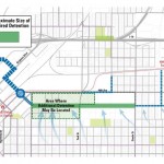
The dark green box shown in the upper left corner is the approximate area needed for detention.
Alternative 2: Open channel with detention in City Park Golf Course
Water needs to be collected in order to get it the Globeville Landing Outfall (the big blue circle and arrow pictured above). During a 100-year storm event, there are flows twice the size of the South Platte coming into this area. It is not feasible to put enough stormwater inlets into the streets to collect all this water. The only way to collect this amount of water is to create an Open Channel to safely collect the volume needed. The green/blue (east/west) line above shows the approximate location. At this phase in the conceptual planning process the exact alignment and width of the open channel are unknown. A multiuse trail connection will be incorporated along the entire length of the Open Channel. This also creates an opportunity to connect 39th Ave to improve the connectivity in the Cole and Clayton neighborhoods.
Even with the Open Channel additional detention is needed to accommodate the water flow through the Lower Montclair Basin. If detention in the Cole neighborhood were to be selected (alternative 1) it would be approximately the size of 3 city blocks and could be placed anywhere within the light green hatched area shown above. There are several different options/configurations as to how this could look.
Detention in City Park Golf Course (alternative 2) in the northwest corner would be a mostly dry detention pond, seeing water only during storm events. This is already a low point in the golf course so the area would need to be a little lower and wider than it is today. There would not be large berms on the edges, but rather it would be dug down to preserve unobstructed views into the golf course. The golf course would be sculpted for interesting play while accommodating detention in order to improve current course conditions.
Since detention areas are being considered in two of the main central Denver golf courses, the goal would be to phase the improvements to make sure at least one entire golf course is always open through construction.
Summary of Lower Montclair Basin Alternatives
| Project Goals & Objectives | City Park Golf Course | Cole Detention |
|---|---|---|
| Reduces property acquisition | X | |
| Opportunity for more water quality | X | X |
| Provides new neighborhood amenities (parks and/or trails) | X | X |
| Reduces tree impact | X | |
| Provides additional stormwater protection for neighborhoods | X | |
| Minimizes future infrastructure costs | X |
Project Schedule
The project will progress in phases as shown in the following timeline (updated November 2015)

This project began planning in the Fall/Winter of 2015. Construction is expected to begin on some areas in 2016 and continue through 2018.
Stormwater Systems Focus
- Storm drain and open channel improvements between the East Rail Line (38th & Blake Station) and the South Platte River (Globeville Landing Outfall)
- Stormwater detention/conveyance between the East Rail Line (38th & Blake Station) and Colorado Blvd. (Montclair Basin)
- Stormwater detention/ conveyance immediately east of Colorado Blvd. (Park Hill Basin)
- Defining the hydraulic analysis for the entire Montclair Basin
- Development of alternatives to address flooding in the lower and upper Montclair Basin
- Identify opportunities for storm water detention and water quality improvements
OSP Materials
Information on Globeville Landing O
![]()


Comments
Platte to Park Hill: Stormwater Systems – 1-27-16 — No Comments
HTML tags allowed in your comment: <a href="" title=""> <abbr title=""> <acronym title=""> <b> <blockquote cite=""> <cite> <code> <del datetime=""> <em> <i> <q cite=""> <s> <strike> <strong>